Our Project

Project Highlights
The Koonenberry Gold Project is considered prospective for large scale intrusive gold mineralisation and has geological similarities to the Stawell Zone of the Delmarian Orogen², located in western Victoria, which has recorded gold production that exceeds 163t. The existence of a substantial gold field overlying the exploration targets is considered to enhance this as an exploration target. Koonenberry Gold has identified sufficient geological evidence to indicate potential for orogenic and placer gold mineralisation supported by the following project highlights:
- Historical artisanal production exceeding 1,870 kg of gold¹ sourced from many relatively small lode and alluvial gold sources and described in records kept by the NSW Department of Primary Industry.
- Deformed turbidite sequences that correspond to those extensively exploited for gold in Victoria.
- Extensive mapped auriferous quartz vein systems.
- Extensive placer and palaeoplacer deposits, currently being exploited by prospectors and fossickers and reportedly yielding significant quantities of gold.
- The presence of the west-northwest trending Koonenberry Fault, that apparently provided fluid pathways.
- There has been no effective testing of the mineralisation to date.
- Numerous geochemical soil anomalies in association with splay faults off the Koonenberry Fault
¹ Geological Survey of New South Wales, Bulletin 32(5), 2003
² Greenfield JE & Reed WJ 2006. Orogenic gold in the Tibooburra area north of Broken Hill- an extension of the Victorian goldfields? In: Korsch R.J. & Barnes R.G. compilers. Broken Hill Exploration Initiative: abstracts for the September 2006 conference. pp. 60–69. Geoscience Australia Record 2006/21

Location and Tenure
The Koonenberry Gold Project is located in north-western New South Wales, approximately 160km northeast of the major mining and cultural centre of Broken Hill and 40km west of the opal mining town of White Cliffs. Good access is available via main roads connecting Broken Hill, White Cliffs and Tibooburra.
The project covers an area of about 1,339 km2 comprising a total of 12 Exploration Licences all of which are in good standing. The licences are held beneficially by 100% owned subsidiary company Lasseter Gold Pty Ltd.

Geology and Mineralisation
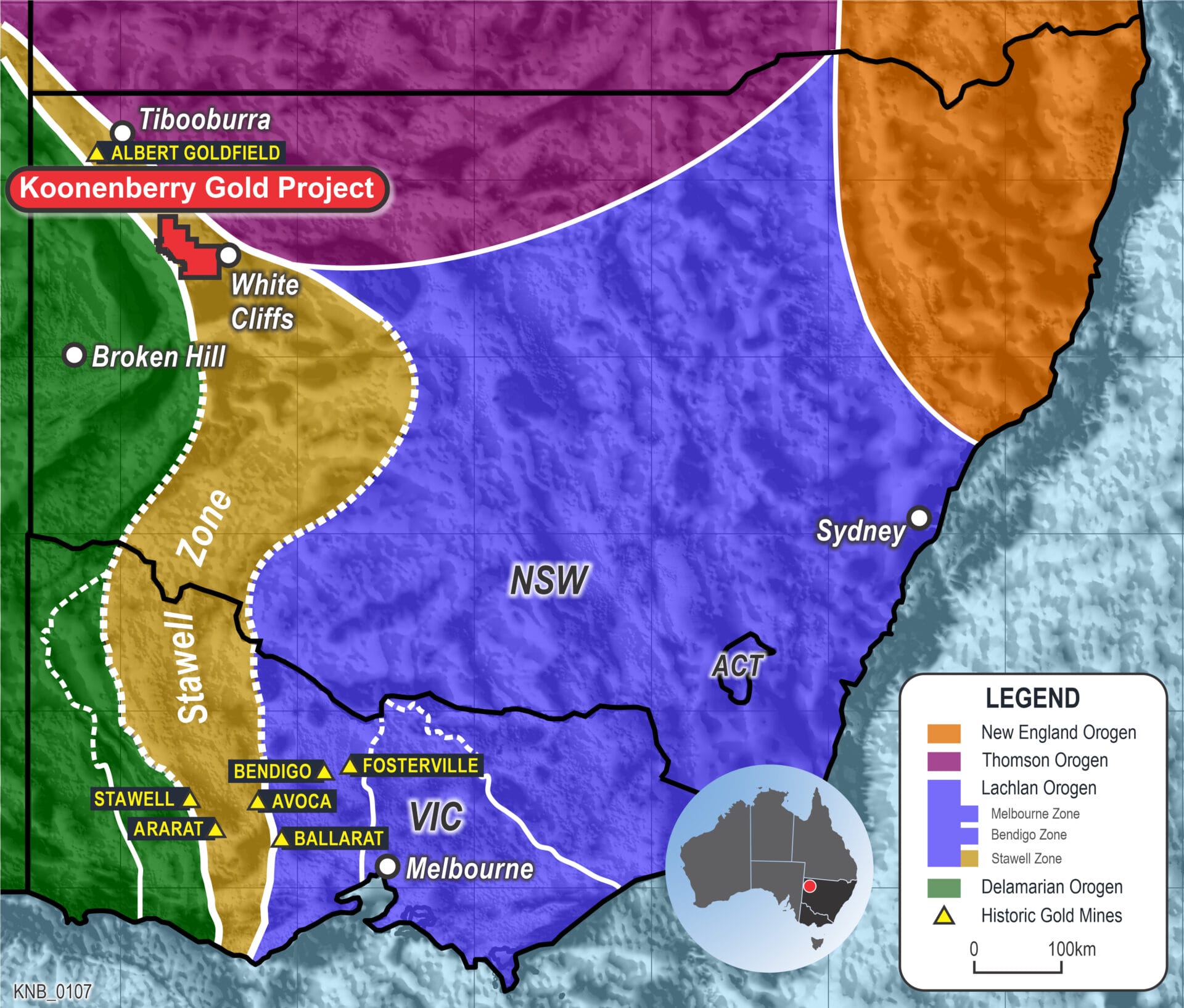
The Koonenberry Belt is an orogenic belt with the potential to become a major new mineral province. The lithostratigraphy, the structural style, mineralisation timing and tectonic setting all point favourably to a comparison with the Western Victorian Goldfields and the likelihood of the Project area being a continuation of the Stawell Zone. The mineralisation styles range from lode style to alluvial and deep lead mines.
The Project area covers a series of Mid-Cambrian marine sediments of the Teltawongee and Ponto Groups, which were deposited in a volcanic arc environment prior to being deformed in the Late Cambrian Delamerian Orogeny. This orogeny is characterised by intense compressive deformation, resulting in tight to isoclinal upright folds and a vertical slaty cleavage.
Koonenberry Gold has spent over
$4m defining targets to date
Target Summaries
Exploration is considered to be early stage, with new prospects being identified during reconnaissance mapping and soil sampling.
Drill Ready
Lucky Sevens
Lucky Sevens is the most advanced prospect, with costeans and drilling over a very short strike length of the >2.5km structure.
The information is concentrated around earlier RAB drilling. There is outcropping mineralised reef and soil sampling has been effective in defining the mineralised trend of the vein system. Geophysical resistivity techniques have been partially successful in identifying the steep easterly dip of the structure, which continues to the northwest of the drilling area.
- Outcropping mineralised reef.
- High tenor grades.
- In subtle demagnetised zone.
- >2.5km strike open along strike and at depth.
- Corridor defined by soils, auger, nuggets and some drilling.
- Costeans and shallow drilling over only a small portion of the 2.5km strike length.
- Defined mineralised trend of the vein system.
- Sighter Bulk Sample Testwork.
Other Priority Targets
Old Bunker TankThe Old Bunker Tank area has strong indications of mineralisation and is favourably sited for both orogenic gold and alluvial mineralisation.
Mapping has revealed carbonate spotting, pyrite euhedra, and bedrock bleaching alteration. An anticlinal fold hinge has been mapped which appears to correlate with the zone of sulphide enrichment in bedrock. Mafic rocks of the Bittles Tank Volcanics are exposed along the fold hinge.
Rock chip samples up to 4.07 g/t Au have been recorded and a 31.2 g/t bulk sample result was obtained from a costean. The high concentration of alluvial gold in the current drainage pattern suggests that the mineralised Bouncer Reef is shedding directly into the drainage at Bunker Gutter.
- Very high concentration of nuggets close to source.
- Alluvial and reef gold discovered.
- Bulk sample 31.2 g/t Au. Rock chip 4.07 g/t Au.
- Anticlinal hinge with pyrite carbonate alteration.
- Numerous parallel reefs and Mafic rocks.
Royal Oak
Royal Oak has had no historical exploration but reconnaissance exploration has returned encouraging results.
The vein is brecciated and iron rich, and the stratigraphy is tightly folded, apparently typical of the Double Tanks area. Sampling confirmed mineralisation, with up to 10g/t in rock chip sampling and 1m @ 2.69g/t Au in costean sampling (DTCOST03). Mineralisation lies within the Royal Oak Fault zone, and locally trends almost east-west. Some of the highest arsenic enrichments (~1800 ppm) have been identified in quartz vein samples collected from the junction between the Royal Oak and Lonsdale Fault.
Soil sampling returns several anomalous areas associated with the Gilbeys and Lonsdale Faults.
- Nuggets discovered on outcropping reef.
- Rock chip 10 g/t.
- Open along strike and to depth.
- Iron-rich reef system along Royal Oak splay fault.
- Costean result: 1m @ 2.69 g/t (DTCOST03 from 46.5m).
- Never drilled.
Breakaways
The Breakaways target is one of numerous prospects within the Nuntherungie Basin and has been subjected to detailed mapping and sampling.
This target is associated with the NW-SE Breakaways Fault. Breakaways contains a complex array of veins and associated alteration. The Nuntherungie Basin offers the possibility of hydrothermal mineralisation associated with basin development, with remobilisation of fluids during basin shortening. This is evidenced by nuggets, stream sediment anomalism, and multi-element lag sampling anomalism. Mineralised veins are evidenced with 2-12g/t Au.
- Mineralised veins with 2–12 g/t Au.
- Associated with NW-SE Breakaways Fault.
- Elevated pyrite carbonate associated with fold hinges and fault zones.
- Detailed mapping and sampling.
Mystery Gully
The Mystery Gully area is a 19th century mining area near Williams Peak, with numerous shafts and adits. Workings exploited the basal conglomerates of the Cretaceous Namur Sandstone.
The Company has processed rock chip samples at the NQM gravity separation facility. Almost all of these samples returned significant results for this style of mineralisation, up to a maximum of 5.62 g/t Au. Gravels in the area appear to be flat lying and no palaeodrainage pattern has been discerned as yet. Hard silicified and/or ferruginised cemented conglomerates and sandstones occur in bands above the gravels, creating a hard cap that hampers excavation. The Company has excavated a number of pits and collected profile samples with bulk sample results up to 5.6g/t Au.
- Deep-lead style mineralisation
- (Paleoplacer Gold).
- Extensive flat-lying conglomerate beds,
- often >1m thick. Gold occurs in gravels and
- conglomerates. Historically mining site. Bulk sample 5.6 g/t.
Atlantis
Well defined alteration with very strongly silicified dome within a hematitic siltstone.
The area is associated with copper occurrences (up to 15% Cu). Strongest Au soil anomaly to date. No previous exploration activities.
- Strongest Au soil anomaly to date; open along strike.
- Associated with copper occurrences (up to 15% Cu).
- Never drilled. No previous exploration.
- Well defined alteration – very strongly silicified dome within a hematitic siltstone.
Lonsdale
Prospective target running NNW @ 1m thick along the Lonsdale Fault splay.
Promising reef sampling has returned 24.1g/t Au and 4.95g/t Au. There has been no previous exploration in this area.
- NNW @ 1m thick along Lonsdale Fault splay.
- Reef Sampling 24.1 g/t and 4.95 g/t Au.
- No previous exploration.
- Discrete soil anomalies.


Four Queens